Monday, September 29, 2014

September 28

September 27, 2014
Left Cedar City after a night of lightning, thunder and incredible rain. I heard on the radio that there were heavy storm warnings south of me (in Hurricane of all places). I also heard later on that the repaired part of I-15 damaged during the first hurricane was again wiped out by storm water.

What a great time to be traveling. Just before Provo, it started raining so hard, I couldn’t see the road. I had to keep track of the white line near the edge of the freeway to even try to drive through. It was like a deluge – a waterfall obliterating every semblance of reality.

When I am in a regular car, not pulling a trailer, no type of weather bothers me: fog, rain, wind, hail, snow, anything. However, not the same in a truck pulling a trailer. I don’t mind the rain and hail, but the wind was awful. When trucks pass me, it is nerve racking enough with the suction of their draft affecting the stability of the trailer. The whole drive from Cedar City to Draper (around 250 miles) was wind buffeting the poor trailer. It tried to wag its tail, but fortunately it kept the wag very small and controllable.

It took quite a while to unclench my hands from the wheel. I’m still a bit sore in the shoulder from the tension of holding the truck steady with the wind, trucks and rain.

I’m set up for the night near Draper, UT. It is supposed to have wifi, but with the tremendous amount of rain falling, it is not working.


I’m not sure when this will be posted, but I will keep it updated until I am able to post.

Thursday, September 25, 2014

Bryce Canyon National Park

Wednesday, I went off to Bryce Canyon National Park. I took the shuttle on the round trip through the first 3 miles or so of the 18 mile length of the road through the park. The first stop was at Bryce Point.
Looking at the Hoodoos (those free-standing spires) and seeing how they start, continue and disappear was fascinating. Reading all the material about them, the geology and history was very informative. The three stages are shown above: 1. Grooves down the cliff face 2. Freestanding arches 3. Hoodoos.

This particular one was above a huge "amphitheater" of trails, trees, hoodoos and more. After riding the shuttle to Bryce Point, I came back in my car to "Inspiration Point." There were three levels to view the spot from, but I was only able to reach the first two. The third was up a relatively steep path (not real steep but at 8300 feet, more than I could do).
If I were young and a hiker (and more in shape!) I would be interesting in hiking these spots. At my age, I can barely breathe at this altitude.

On the way to and from Bryce Canyon, you drive through Dixie National Forest. One of the stops is at Red Canyon. The road goes through two "tunnels" that were dug through a couple of rocky places. They were both about 10 feet long. At the visitor center, there is a short hike to see the Hoodoos close up.
Also on the way back, the road goes up into the subalpine area with the aspens. I found this little dirt road on the way back and took a short drive before I turned around. The colors are glorious.
I was tired when I got home (76 miles each way of driving and all the walking around) so Thursday (today) is a rest day. Friday will also be a rest day, since Saturday I am leaving.

Today, I made shades out of cloth used to darken rooms to replace the plastic, broken up shades in the trailer. No more holes in the shades. Some of them were big enough to stick your head through and made me far more visible than I would really have wanted to be.

Wednesday, September 24, 2014

Zion and Cedar Breaks

There must be a law in Utah that says you are required to go 5 to 15 miles an hour below the speed limit, especially in the hills. The number of cars behind you doesn't matter. If they want to go faster (like maybe the speed limit), they have to pass, but only in the very short passing zones, if there is no traffic. And rule number one, you must NEVER pull over to let anyone pass.

Or, you go 5 to 15 miles per hour faster than the posted limit and force others to pull over to let you by before you ram their back bumper.

End of rant.

Tuesday, I went to Zion National Park, Kolob Canyons. I did the short hike at the end of the road to the overlook. Looking at the canyon from that level was overwhelming. The beauty was breathtaking and not just because of the altitude.
I spent an hour getting to the top and back (I walk very slowly) and then drove to Cedar Breaks National Monument. Zion Kolob Canyon is 20 miles south of Cedar City (where I am right now) and Cedar Breaks is 25 miles northwest.

A year ago (right after I got my camera), I had made plans to visit Colorado in time for the color changes in the aspen trees. I cancelled that trip because of the flooding in Colorado at that time. I guess I wasn't looking in the right place.

The altitude at the visitor center at Cedar Breaks is 10,500 feet above sea level. Talk about breathtaking. This time is was the altitude.

But a big part of it was looking over the railing at the visitor center and seeing the surrounding area. OMG, it was scary looking over, but the view was even more taking-away-my-breath and it wasn't just the altitude.
But back to the aspens. At the altitude of Cedar Breaks and the pass leading up to it, I was at the "subalpine" tree level, which includes aspens. 

The green, reddish, orangish and golden colors of the aspens at this altitude were absolutely incredible. I couldn't take enough pictures. But I did take enough to realize I don't need to go to Colorado to see the trees.
I had to leave Cedar Breaks fairly quickly because I couldn't breath at that altitude. But it was a great side trip, nonetheless.

Monday, September 22, 2014

Moving Day

This is going to be short and with no pictures. Those will come tomorrow.

I left Boulder City, NV at around 8:30 am. Less than 200 miles later, I arrived in Cedar City, UT at around 12:30 pm. It was an easy drive, all up hill, but gently up, nothing horrendous.

It was one of those times when I wished I wasn't driving. The change in environment from Nevada to Arizona to Utah is truly amazing. Nevada is desert - flat, no trees, nothing more than 1 foot tall, the hills were rocky with nothing growing. As we got close to the Arizona border, the landscape became more hilly, more rocky and even the desert part was different.

Different kind of brush (taller), hills had more colors, the hills were buttes, bluffs, and table mesas with differing colors of rocks. There were places where you could see the various levels at which the colored layers changed. Mostly they were straight and level, but every once in a while you would see a section that was slanted or distorted into almost a loop.

I studied basic geography and oceanography and understand the tectonic plate theory. The idea that the Sierras are growing taller because the Pacific Plate is diving under the North American plate and forcing the left coast higher is fascinating.

Having watch Discovery about how the earth was made drove my thought during this drive. What kind of forces are underneath a particular place that make it change from straight and level to slanted and looped?

So, just a "short" drive and cooler temperatures. And I can't seem to get the trailer perfectly level. It is close enough to keep everything operating, but I don't have the energy or strength to make the jacks any more level. Maybe tomorrow.

Sunday, September 21, 2014

Saturday Night in Vegas

Saturday night was a loud night. No partying but the lightning, thunder and rain (yes, rain) pounding on the top of my aluminum home were all loud. Nice light show, but the rain was unexpected.

It started out as a little pitter patter on the roof. Then the hammer of Thor started pounding the roof. Then pitter patter for a while, no noise for a while and then Thor came back to pick up the beat.

It lasted for quite a few hours, but was something to keep me awake for a while.

Today is Sunday and tomorrow morning I will be hitching up and heading out to Cedar City Utah. It is cooler there than in Vegas, so it should be a good, easy trip.

Picture that didn't want to be in yesterday's blog.
This is the Bellagio water works when it is not working. They don't run it during the day. Too bad. Even in the daylight it would have been beautiful.
I noticed these two wings on one hotel (didn't get the name) and the buildings are slanted in different directions. Neither building appears straight, but from looking at the glass panes, they are obviously built straight but the walls on the outside slant.

Saturday, September 20, 2014

The Vegas Strip

I went to the Las Vegas Strip Thursday. I'm still trying to digest how I really feel about the area.

My first thought is: This is awful. Why is this so popular?

(BTW, I'm having trouble right now uploading pictures. When I get a stronger signal, I'll edit this with pictures).

I parked at the Paris Hotel and then walked up to New York New York.

The best thing about the Strip is that at most intersections, there is a walkway across the street so you don't have to be at street level and wait for the lights. You do have to go upstairs (or upelevator or upescalator) to get to the walkway, but it is accessible.

I saw the Bellagio waters without the show. I guess it is only done at night. I saw a bunch of other hotels and their huge overly bright neon signs. I walked south on one side of the street, then crossed over the street and walked south back to my car.

It was hot and crowded. Among the non-hotel sites were the characters in costume. Most of them were in full costume, but the costumes were old, poorly maintained and obviously a costume. I still felt sorry for those that were fully dressed in the heat and sun on that day. The ones I didn't feel sorry for were the few girls I saw wearing as little as legally possible and the "gentlemen" wearing even less. There was no shrinkage visible, in fact, it seems, the opposite.

Today, I went to the Railroad Museum and rode the train. It was interesting looking at the old cars and looking inside an old Post Office car and a caboose. It wasn't as hot as the previous days, so the breeze created by the train ride felt good.


The day started out cloudy and has continued to get cloudier. The temperature is cooler, by a few degrees.

I'm going to be leaving Vegas and Nevada on Monday and heading into Utah. I'm planning on visiting Zion and Bryce National Parks. From there, maybe off to Moab or maybe farther north. I'll see how I feel.


Tuesday, September 16, 2014

Vegas, Again

I wasn't going to do much today, but I ended up going to Hoover Dam. I had been there when I was young and only remember the horrendous elevator ride to the bottom. Didn't do it this time.

Looking at Lake Mead on the way, you can see the "bathtub ring", the highest level of water (and usual level). The lake level is so low, islands that were originally covered up have surfaced.

I drove to the dam, and they have security checking vehicles on the way to the dam, assuming that you are going to cross it. Since I wasn't interesting in driving across (bridges are bad enough, doing the dam would have been too much), I didn't mind showing what was in my truck. Lots of junk.

First thing I saw as I drove down the road to the dam was this tower that carried wires from the base of the dam up and over the hills surrounding the dam.
No, they aren't broken, they were installed in this angled way. Looks weird, like they are in the process of falling over.

I walked along the dam and had to take my cap off so it wouldn't disappear into the water below. It was an OMG moment looking over the side at the dam. It is a long way down.
I walked to Arizona and then walked back to Nevada. Not so long a trip, since the Nevada/Arizona line is in the middle of the dam.
Walking back on the other side of the road, I saw this little memorial. It might be difficult to read, but it was for the mascot of the builders of the dam. He apparently had been killed when a construction truck hit him. This was very sweet of the men who spent so much time and energy on this project.


BTW, it was very hot. Did I mention it was HOT??? It started clouding up when I got home, and around 7:30 pm I went outside to watch the lighting. It was only in the clouds (didn't seem to be hitting the ground), and I didn't hear any thunder. It was also very windy (rocking the trailer). Maybe we'll get a little rain. It is supposed to be a tad (a degree or two) cooler tomorrow. Maybe not even hitting 100!

Vegas Baby!

Sunday morning I went from Fresno to Barstow. The pass was horrible - it was hot and long. My truck got very warm so I turned on the heater (!) on to help reduce the engine heat. I gave the cats a bottle of ice each (I had frozen water in used water bottles). They finally shutup after that.

I spent the night in a little park that I saw reviewed. The owners were very helpful and friendly. I didn't even unhitch or do much of anything. I couldn't get on the internet, so I couldn't do anything on my computer.

So I left Barstow very early this morning and it was already warm. Coming out of Mojave, it was a long (16-20 MILES) of uphill climb. It was also very straight and very up. I went slowly, trying to keep the engine temperature down. It got warm, but didn't overheat. Of course, I didn't have the air conditioner on until we finally started heading down.

At the border between California and Nevada is a huge solar array with a reflector to focus sun on the array. It was very bright with lots of "silver" surrounding the reflector. There was also a lake around the reflectors, maybe from the last storm that came through.

You can sure tell the difference between California and Nevada. The first exit in Nevada had a full-on casino, hotel, and amusement park going on. In the middle of the desert. The next exit (14 I believe) had the same and a huge sign saying "Come in here. Spend your money here!"

I arrived in Boulder City around 11:30. First thing I did was plug the power in and turn on the air conditioner. I put the awning out and it is rocking the trailer now because the wind has picked up. I will probably have to pull it down.

Time to rest and stop sweating. I'm drinking lots of water and it all seems to come out as sweat.

Saturday, September 13, 2014

Hitched up and ready to go

I hitched up the trailer to my truck and just need to remove the electric and the water and put the antenna in the trailer and then I am off. My plan is to leave very early on Sunday morning to avoid the heat going through the desert.

I'm going to stop overnight in Barstow, because it is a long haul to Las Vegas and I really don't want to be doing that with the potential heat out there.

It is a little cooler and windier today than it has been, but still warm. The place I will be going may not have internet, so this may be my last posting until I hit Vegas. I'm actually going to be staying a week in Boulder City, which is close to Hoover Dam.

I'll probably visit there and make a day trip into Vegas, but beyond that, I haven't decided what I will be doing once I get there.


Wednesday, September 10, 2014

Sentinel Dome

Just a moderate hike, they said. Just 400’ altitude climb, they said. What they didn’t say: That 400’ was the last .1 mile, up to the top of Sentinel Dome. I hadn’t hiked to the top of Sentinel Dome since 1973. The distance was 1.1 miles (one way). A moderate hike, only 400’ of altitude increase. Hah!

Well, I did it, mostly to take a picture of the Jeffrey Pine that was an iconic symbol of Yosemite. I took this picture in 1973 when the tree was healthy and growing well into the granite at the top of the dome. You can see Half Dome on the right, under the outstretched limb.

Here is the same tree and (nearly) the same view today. As you can see, Half Dome is almost hidden by the smoke from the current fire. The tree is down, where it fell in 2003. It died during the drought of 1975-1977 and took until 2003 to actually fall. It had lived for a long time, but couldn’t endure the drought and lack of snow during those years. So tragic. But new, younger trees are growing so far. Hopefully, the current drought won’t kill them, too.

The fire. It isn’t close (Little Yosemite Valley, below Half Dome on the right – you can see the heavy smoke from the fire), but the smoke was hard on the lungs. I coughed all the way home, trying to clean out my lungs. My eyes burned for a while, until I was able to get out of the smoke. The valley was almost impossible to see because of the smoke. Two paragliders took off from Glacier Point and disappeared half-way down in the smoke.


Most of the smoke seems to have hit the valley. I’m so glad I was able to visit the valley last week when it was clear. I got home shortly after 1:30 and my left knee is really feeling the hike – thank ceiling cat for ice!

Monday, September 8, 2014

Relaxing in Fresno

It rained last night, for about 10 minutes. Hard and short lasting. Also very warm for being so late in the evening.

It rained again a couple of seconds ago. For about that long. It is very cloudy and still very warm, so it is feeling more humid than usual.

Not doing much of anything today except cleaning and reading. I realized that I don't have to do anything or be anywhere at any particular time, so I stopped worrying about doing nothing. I'm enjoying it right now. I may not feel the same later, but right now, I'm learning to enjoy it!

Have a lovely day.

Sunday, September 7, 2014

Sequoia National Park

Yesterday, I drove to Sequoia-Kings Canyon National Park(s). What a change from Yosemite.

Yosemite Valley is set up for tourists. Its popularity is probably its downfall, but with the changes to limit the impact of people, it may do better. There are still too many places where the environment is less important than giving people a pleasant experience. However, everything is in a limited area. Yosemite Valley is the valley. One way in and out. Glacier Point on one side is a very long cul-de-sac. Tioga and Tuolumne Meadows are the other way out of the park, to the east, separate from the valley.

SKC is a trip around the mountains on the west side of the Sierras. No way across the mountains to the east. No one localized tourist area, it is spread over the whole road. At several places, there were pictures of how the tourist areas have changed over the years. Very few areas are as extensively touristy as in Yosemite, but no large areas of development are evident in SKC.

One of the first places I stopped was at the General Sherman Tree. It is called the largest tree by volume in the world. There is a trail from the parking lot to the Tree and along the way are markers indicating how far up the tree you would be located if you could walk up the tree.
The trail was paved and all down on the way to the bottom. There were stairs situated all over the trail to make it less steep, but it was still hard on my knees.

It was a gorgeous walk (can't call it a hike, because it was so beautifully maintained). The atmosphere was clear, clean and smelled wonderful. Until some fool came along with his cigarette. Who walks in the forest smoking? How disgusting.

Made it to the bottom and was overwhelmed by the hugeness all around me. Some people feel small when they look at the stars. Some people feel small when they see long-lived, huge trees. Some people feel they are too powerful, rich, whatever to feel small compared to anything else. Sad.


My next stop was at the Giant Forest Museum. Reading all the exhibits and standing inside the hollowed out (replica) tree was fascinating. There was a short trail over to the Round Meadow/Grove area, so off I went. It was another easy walk, but a bit longer. Also, no steps, it was mostly level. This is an area that has been reclaimed since the meadow had been ringed by cabins, and the museum had been a market with a gas station nearby. The gas station was gone, as were the cabins. According to the exhibits, the property had been purchased from local owners and turned over the NPS in 1916.

It was a quiet, interesting walk. There were a lot of signs showing information about the area - fires scarring trees, fallen trees, wet meadow land, etc. It was an informative, easy walk. I apparently was walking in a different direction than everyone else, but it was not crowded.

I saw this tree next to a boulder and wondered if the tree was trying to eat up the boulder. Just a funny on the way back to the museum.

Left the park after this little hike because it was getting very warm. The road shown on the park map was very twisty and the sign indicated a steep road with lots of squiggles. It was fortunate that I was driving because I would have been a very car sick passenger. The squiggly sign at the top doesn't begin to do it justice. In several places, I felt a small frisson of terror because the road dropped off with very little shoulder and the road was not that wide.
This is a view from one of those drop offs. No trees to catch a slip off the road and a long way down. I had never been to SKC before, so it was an interesting experience. I think it is one that needs to be shared at the time with someone else. That is one of the problems with traveling alone!

Wednesday, September 3, 2014

Yosemite - Finally

Correction: I attached the whirlygig to a CHAIR, not a CAR.

At 0-Dark-30 (actually 6:00 am) I was on the road to Yosemite. Cool and no traffic! Lots of traffic going the other direction, though!

I watched as I was driving at the sky turning pink over the foothills and into the mountains. Driving past the dry, barren flatlands up to the dry, barren rolling hills, I realized that part of the problem was that it was hot and getting close to winter and another part was the severe drought. Poor California!

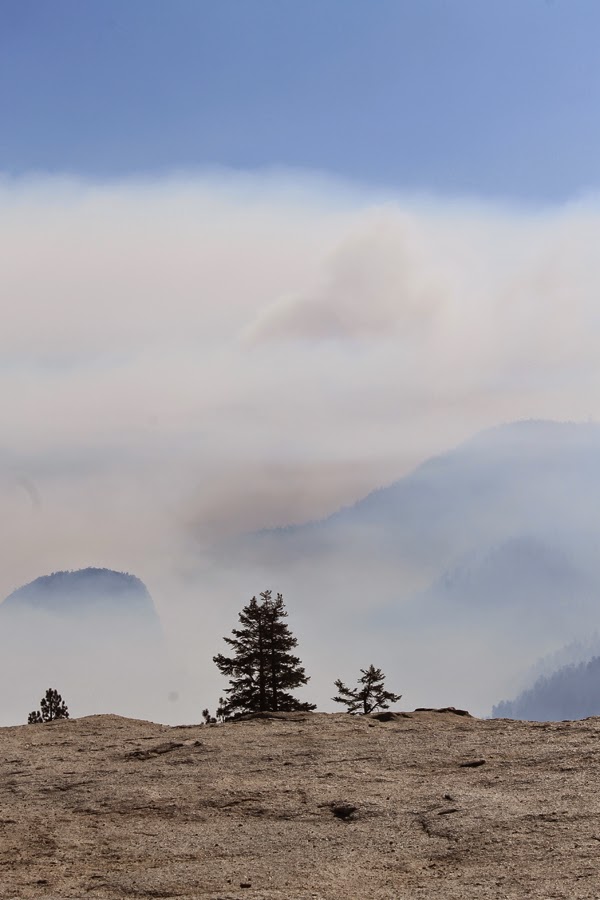
I reached Yosemite fairly quickly, and made a stop at Inspiration Point. The valley was nestled in a covering of either mist or smog/smoke – either of which looked kind of pretty. Mist would burn off, smog/smoke would get worse. It got worse later on. Other than that, it was a gorgeous day – no clouds, kind of cool, at least in the morning.

I reached the valley an hour later and drove on the north side of the valley. I parked near Yosemite Village and took the shuttle to see where I should go. I decided the Mist Trail (or at least to the bridge) would be the trail I took.

A brief word here about Yosemite and the changes that had been made. The last time I was here (late 60’s?), National Park Service was giving a survey to every person who came through the valley to find out what they would like to see changed or remain the same in the Valley.

After a flood, earthquake and lots of rock slides, changes were made. Lots of changes. Roads were closed, parking limited and a shuttle is the best and easiest way to get around. Trails were rearranged and parking areas removed. It is no longer possible to drive to Happy Isles or Mirror Lake. Yosemite Falls has an entirely different arrangement now.

It used to have a huge parking lot at the end of the path to the falls. The path was a straight shot to the falls, so once you passed the canopy of trees, the falls opened up. Now, the parking lot is gone and the path has split into two, neither of which has the same open feeling it used to have. That is so sad. The fact that there is no water in the falls is even sadder.

The Rangers were saying that even Bridalveil Falls didn’t have water, but I took a picture early in the day that showed a small amount coming down. But you can see where the water was supposed to be, especially Yosemite Falls. This is a picture of Bridalveil Falls. Doesn't look like a bridal veil, does it!

So I rode the shuttle to Happy Isles, after stopping at my truck to get a walking stick and my small backpack. I went to the Happy Isles and ate a little lunch. Then I went up the trail to the bridge below Vernal Falls.

The .80 mile trail is .75 miles of up with .05 miles of down on the way to the bridge. It was hot and I did a lot of stopping on the trail, always trying to stay in the shade while sitting. There were a lot of sunny places and it was just too hot to sit in the sun.

I discovered that I am hideously out of shape. Disgustingly out of shape. Sorely out of shape. But by putting my treadmill on stroll, I was able to make it to the bridge. If you look closely on the left side of the granite between the trees you can see Vernal Falls, maybe an eighth of its normal size.

Then came the real problem. Going down. That .80 mile was .05 miles up and .75 down back to the road. My left knee isn’t well enough to support that much downhill, so I had to sit and try to work out the pain on the way down.

Yeah, yeah, yeah. Bitch and moan. I met a lady and her 70 year old sister who had just had two operations within the last year and she bravely made it to the bridge and back without complaint. I stopped complaining after talking to the two of them.

Although I was tired, hot and hurting, I tried to visit a couple of other places, but it was beginning to get to be too much. I did stop at Inspiration Point (now called Tunnel View) on the way out of the park and got some afternoon pictures to match my early morning shots. You can see the clouds in the distance just starting to come in.


Thus ended my first foray into my great adventure.

Monday, September 1, 2014

Start of My Great Adventure

First full day of Fresno. It is really hot, but I am finally able to use the canopy that I paid to get replaced on the trailer. Sitting in the shade, in my rocker, reading my Kindle is the perfect way to do absolutely nothing. Of course, that is exactly what I will be doing the rest of the day and maybe even tomorrow.

I bought a whirlygig at the Alameda County Fair and attached it to one of my cars. It mostly is still, but every once in a while it whirls into a blur.

Here's a picture of my new setup.

As you can see, lots of concrete with some lawn (being watered early in the day). Not a lot of shade, not like Eddos!

The biggest problem is the almost constant traffic noise during the day. Don't notice it so much at night. Actually the biggest problem is the heat. Running the air conditioner even at night is not fun (very noisy). 

Further plans include a trip to Sequoia as well as one to Yosemite. Because it is so hot so early, I will have to leave before sun-up to keep cool. The cats have it made - they will be staying behind in the air-conditioned trailer. Lazy beasts!