Monday, December 14, 2015

December, 2015

I left Crescent City on December 1. I drove up to Cape Blanco State Park, since I was due there to start my winter camphosting position. The weather was so-so, not hard rain, but sprinkles here and there. The road (Highway 101) turns into a narrow two-lane road north of Crescent City and into Oregon.

Before I left Crescent City, I spent several days walking around the harbor and enjoying the ocean. The weather on those days was wonderful – not too cold, not too warm, sunny and enjoyable.
I saw sea lions, watched a dog playing and watched the waves from the pier.

There were a lot of places to visit, but I only went down to Redwoods National Park south of Crescent City. This is one of the places that I had applied to be a camphost, but I never heard back from them.
So, in Cape Blanco State Park since December 1. Since December 1, there are been a couple of days of no rain, and on days with rain there have been a couple of hours of no rain. In other words, I am growing mushrooms between my toes. Some of the rivers inland are flooding because of the constant rain.
I took some pictures on the day it didn’t rain, but I haven’t been able to repeat the effort, since there hasn’t been non-cloudy and non-rainy days since then.
All those trees surround the campground, so you can kind of see where the camp is.

Leaving the Bay Area

I finally left the Bay Area. I spent the night in Ukiah at the fairgrounds. It was quiet, except for the freeway about ¼ mile from the park. There weren’t a lot of people there, and no wifi at all.

I left the next morning to go to Rio Dell. It was a relatively short trip, made a bit longer by my side trip to the Avenue of the Giants. Dragging a trailer on that relatively narrow, very serpentine road was not fun but the area is gorgeous. The park where I am staying has cable TV but no wifi. Fortunately, the nearest Burger King with wifi is only 10 miles away.

I visited Ferndale – the “Victorian” town. The gingerbread on a lot of the buildings in the downtown area are maintained and painted in gorgeous colors. The bridge over the Eel River is very narrow, but the town itself is lovely.

Then I drove down to the Avenue of the Giants to visit some of the groves. It has been so long since I have been here, everything has changed (except the groves). The Dyerville area has been turned into an overlook and is all grassy and posted with information signs. It was just a dirt filled area when I was here last.

I went to Founders Grove and took the short (1/2 mile easy walk) through the grove. It was peaceful (only saw a couple of other people) and mostly quiet – since the highway is only a mile or so away from the grove, it was possible to hear traffic, but it wasn’t real loud. The air was clean and fresh smelling and I could hear the birds singing in the trees. Didn’t see any, though.

Took a quick picture of the high water mark from 1964. It is about 20 feet high at this point, 90 feet above the river. After the devastation of this flood, a lot of work to protect and redo the watershed has led to such occurances not happening again.


I’m not going to stay here the three weeks I thought I would. Not having wifi here and having to go 10 miles away to get wifi limits the amount of time I can actually keep up with what is happening. So, I’ll be leaving on Tuesday to go to a park that has wifi. 

Thursday, November 12, 2015

Update 2

For the last month, I have been in the SF Bay Area. “Home” if you will. I haven’t been this unhappy for a long time. Most of it has to do with the traffic – too many people, too much traffic, just too much.

I had planned to go elsewhere until the transmission in the truck decided it had better things to do. So that took 10 days to fix and a whole lot of money. I was able to get it fixed, but now I’m paranoid about the engine. I’ve been taking it easy since the repair.

I really haven’t been doing much of anything but getting a cold and finally ending the cough that always shows up after a cold. I saw my doctor, got the physical and blood tests and I’m pretty healthy for an old person.

Ran a race at Golden Gate Fields. Yeah, not on the track, but a 5K race that finished up at GGF. Actually ran some of the race and set a new record for myself! Being at 3300 feet all summer probably made it easier to run the race at sea level. Having a cough didn’t help, but I was able to overcome that obstacle.

I am going to be camp host at Cape Blanco State Park in Oregon for the winter. It is a campground and day use area open all year. It is right on the ocean, on the farthest west point of Oregon. I can’t wait for it to start. The position will last for as long as they can stand me or 4 months (until March 31), whichever comes first. I start December 1, so between now and then, I’ll be making my way north through the Redwoods.

If I can get internet service on the trip north, I'll keep this updated.

Sunday, November 8, 2015

Update

2015-09-26   I went up to Lassen the day after I arrived in Red Bluff. Because it was after the end of the season, the campgrounds were closed. I wasn’t going to camp, but it was interesting that the places were closed already. It had been so long since I had been there, I really didn’t remember anything.

 My plan was to go to Bumpass Hell and then find a couple of other trails to walk. That didn’t last long, because my left knee decided anything named Hell was going to be where it was going to take me. The knee hurt too much to do much walking after the Bumpass Hell trail.

It is a rocky trail going up to start, relatively easy up, rocky and, early in the morning, an easy hike. However, the down part after you reach the summit was a lot steeper. Which means, you get it, coming back would be harder.

Bumpass Hell (in case you haven’t noticed, I love the name) is an area of bubbling pools, farting vents and a general, overall, sulfurous area. It was named appropriately. There was a boardwalk, the last bit of it closed for repairs. I was one of only a couple of people there, so I was able to take my time.

I slowly climbed back up the mile or so to the top and the rest was an easy, not very steep downhill to the parking area.

The next place I went was to the devastated area. The last eruption was in 1916 and “devastated” the area a long way down. Now the area is mostly regrown and it is a little difficult to see where the devastation happened. There were a lot of big rocks thrown out during the eruption, a couple of miles from the mountain. There was a short interpretive trail showing the devastated area right after the eruption and some of the “erratics” (rocks that shouldn’t be where they were). Informative and hard to believe that it had been so destroyed.


Lassen was quiet and peaceful during my time there. The NPS and Lassen will celebrate 100 years next year. Should be fun!

Wednesday, September 30, 2015

Goodbye Montana, Hello California

Sunday, September 20 was my last day working at Whitefish Lake State Park. It was a bittersweet kind of day – glad I don’t have to clean bathrooms any more, but I will miss the great fun I had at the lake. I took one last picture of the lake – the level has considerably dropped from when I arrived.
The people I worked with were fun – I probably laughed more with these people than I have in a long time. Working with Ron was fun. Cecil, Larry, Grace, Tommy and Dave were interesting to talk to and to have some weird conversations with. I will miss them. Do I want to go back? Yes, as long as I don’t have a train running over my head every couple of hours!

On Tuesday, September 22, I left Whitefish Lake State Park for my trip to California. I went down 93 until I got to 28 and took that to St. Regis to join up with I90 into Washington (Spokane). I was glad I was going that direction, since I-90 in my direction was a lot more down than up. I couldn’t even imagine going uphill because there was a long stretch of downhill on my side that would have stressed my poor truck to no end going the other direction.

Just before Coeur d’Alene, the sky filled with smoke. It tasted like smoke and irritated my eyes. After a half hour or so, the smoke went away.

I stopped at a small “RV park” near Sprague (south of Spokane) and spent the night there. It was an open field with water and electrical hookups. The bathroom was inside the building and closed around 8:00 pm or so. No TV signal and no dump available. Oh well, the hash browns were freshly grated and tasted great.

I left early in the morning and made it to John Day, OR, where I camped at the Grant County Fairgrounds.  Full hookups and an available bathroom.

Oh, BTW, did I mention that neither site had internet? I was having internet withdrawal symptoms for a while.

Thursday night, I made it to Klamath Falls after deciding not to continue on 395. I went through Bend and made it to Klamath Falls early enough to relax. There was internet, but intermittent.

I decided to stay a few days in Red Bluff, CA to visit Lassen Volcanic National Park. I was last here in the winter of 1977 with a group of cross-country skiers. We spent the weekend in a small motel and skied through Bumpass Hell and some other areas. Previously, a boyfriend and I drove through the day the road opened (May 31). The snow drifts on the road were 5 feet high!

So I went to Lassen after arriving fairly early (around 11:30 am) and drove to a sulfur pot alongside the road. It was really stinky! The hillside had some other holes farting out their sulfur smells. Not a pleasant way to explore, having to hold your breath!
After I leave here, I’m not sure what I will be doing, but I’m thinking a trip to the coast would restore my spirit like just about nothing else would. Right now it is hot and smoky in Red Bluff, so I think I need the change. It depends on what I might have to do to find a job!

Last Days in Glacier National Park

On August 27, I went up to Logan Pass on the shuttle and hiked the Hidden Lake boardwalk/trail to the Hidden Lake overlook. It was extremely smoky and hard on the lungs. The boardwalk’s steps were very uncomfortable, since they were too high. Going up was bad enough. Coming back down was even worse!
Once I got to the overlook, there wasn’t a lot to see because of the smoke. There is actually a lake down there underneath the smoke.
There were a lot of little creeks and waterfalls towards the top of the trail before the overlook.
On September 3, I took the shuttle to Logan Pass to hike the Highline Trail (at least a small part of it), but it was raining at the top, so I rode the shuttle down to St. Mary’s past all the burned areas. Saw some Big Horns at Logan Pass.
When we got back to the top from St. Mary’s everyone had to wait to get the shuttle going down to Avalanche Creek. It was a sultry 39 degrees, and I was woefully underdressed in shorts and a light jacket. I took some pictures at Lake McDonald looking up toward the Garden Wall.
On September 9, I drove up to Logan Pass where some white stuff had accumulated alongside the road and on the Highline Trail. The shuttle had stopped running after Labor Day, so I had to drive.
On the way down the Going To The Sun road, a mother and baby mountain goat were alongside the road. There was a crowd of people, like papparazi taking pictures of every move they made. The baby looked like it might have an injury, and it didn’t seem particularly willing to join mom who was up higher. Eventually, they went back the way they came and disappeared.

Then, I went on a Ranger-led hike to John’s Lake, past the falls and back to the trailhead. It was an informative, easy hike on a relatively cool day. Saw an interesting tree shape on the hike.

Made what I thought was going to be my last trip to Glacier to take photos of Lake McDonald just before sunset. The trees were on fire. The sky was full of big fluffy clouds, so it was gorgeous.
On September 16, I drove to Thompson Falls State Park and ate lunch near the river. It was a quiet area, but a train runs nearby and managed to blow its horn for a long time. The trees in Thompson Falls (the town) were absolutely gorgeous.

On September 17, I made my last trip to Glacier. I got close to McDonald Creek falls and enjoyed the wonderful environment. I will miss Glacier.

Tuesday, September 29, 2015

Just a note

I've been trying for many days to enter another entry, but the internet connection has been bad to non-existent since I left Montana. So, I have two entries to make, but until I find a more stable internet, I don't know when that will happen though.

Friday, August 21, 2015

Catch Up Time!

I just looked at my blog and realized I hadn’t entered anything in 3 months! Not good! So I’ll try to catch up with what has happened to me during those three quiet months.

First, being at Whitefish is nice. Except for the train, it is quiet and looking out onto an area of trees, grasses, all sorts of green is relaxing. I’m able to put my awning out and most of the time it is no problem, even if it should rain (longest rain has been about 2 minutes). The problem is when it is windy (there have been a few days).

I have been to Glacier many times since I have been here. I went several times during late May and early June. Here’s one of the pictures I took of Lake Macdonald. The breeze was blowing gently and for a few minutes it stopped. This looks like a mirror, but if you look, you can see the rocky bottom of the lake.
I also went out to Hungry Horse Dam. The town of Hungry Horse was actually named after some horses that were lost during a storm and when found were extremely thin and hungry. The dam is quite high and the road across it becomes dirt on the far side. There are some campgrounds around the lake, but I wasn’t interested in continuing on the dirt road very far. Here’s a picture of the dam and surroundings
.On June 11, the Going-To-The-Sun road opened. I was very early going up there and made it to Logan Pass without driving off the road, or into the rocks, or going stark raving crazy (questionable, maybe). At Logan Pass, I took a picture of the snowbank. Remember, this is June 11. The snow had disappeared by three weeks later.
I then went to Lake MacDonald Lodge and took the boat ride around the lake. It was beautiful, but the wind made whitecaps. Doesn’t this cloud look like Snoopy on a flying saucer?
On June 19, the eastern side of Going-To-The-Sun road opened. I went to the east side around the bottom of the park. I visited Two Medicine and took some pictures of Running Eagle Falls. Then, the two parts of the falls were running. I hear later on in the season, the top part of the falls disappears and the water comes out of the bottom part.
I then went up to Many Glacier. It, like just about every place in Glacier, is situated on a lake. The Many Glacier Lodge is 100 years old this year. It is a gorgeous place, in a gorgeous surrounding. The mountains and lake make for a wonderful atmosphere. I took GTTS road back home.
On June 26, the EPIC meetup of Kossacks (Daily Kos people) occurred in Glacier. After a welcome BBQ in Coram on Thursday evening, Friday 
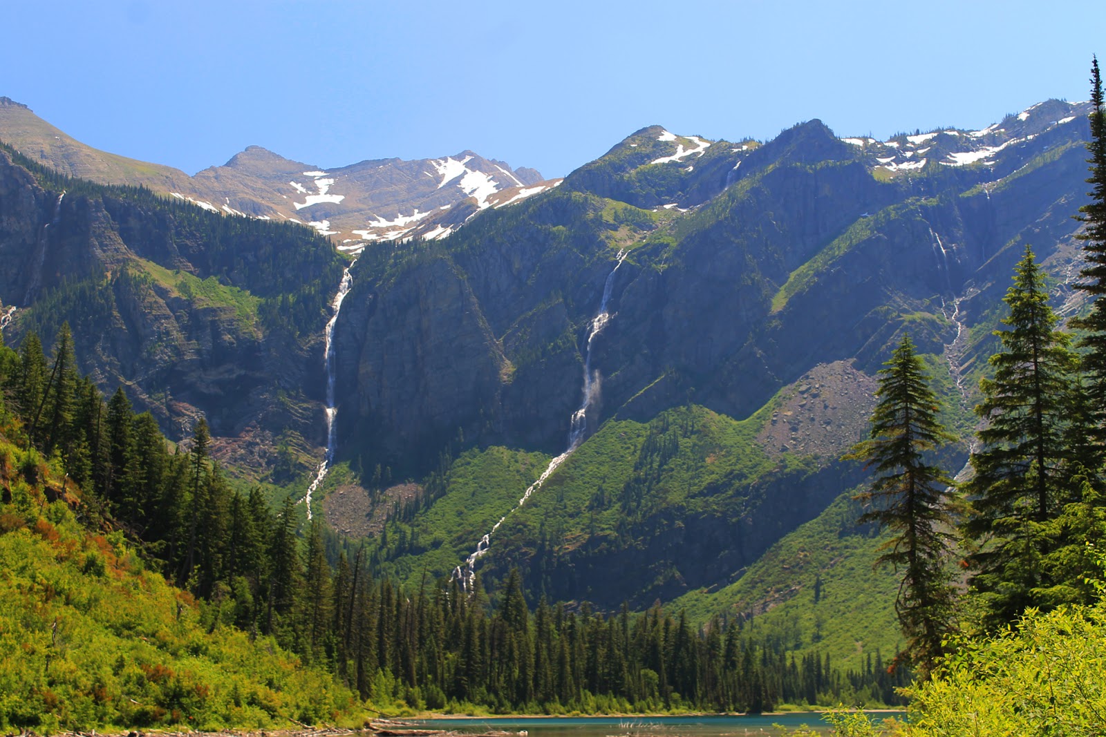
was spent hiking up to Avalanche Lake. The lake is gorgeous and is surrounded by mountains and hanging valleys with waterfalls surrounding the lake. The hike was not that difficult, but the downs were not friendly to my left knee. Later that night, we had a picnic at Apgar Picnic area and I went into the lake to kind of ice down my knee. Shortly after doing that, I ended up with a cramp in my leg. Not fun.

On June 27, we took the Red Bus up to Logan Pass and one of the Kossacks and I went rafting afterwards. Then, dinner at Lake MacDonald Lodge. Wonderful. Expensive, but wonderful. Good company and good food. Couldn’t be better.
On July 1, one of the couples from the meetup and I rode the just started shuttle up to Logan Pass. We wandered around there for a while and then came back. It was great not having to drive myself. We didn’t take the boardwalk but did some off-road hiking. We saw a sheep far away and discovered that the earth was soggy in some places.

I went up to Logan Pass late one night to take pictures of the stars. That didn’t turn out so good. After a few hours up there, I went down to Two Medicine to sleep before the NPS Instameet – a ranger gives ideas for photos, etc. This was supposed to be for the sunrise on the mountains around the lake. But it was so smoky, the sun didn’t really make a dramatic statement on the mountains, which might have happened if it weren’t so smoky.

When I got up to Logan Pass at 10:00 pm or there abouts, there was a herd of Big Horns wandering all over the parking lot drinking either the antifreeze or condensation left on the ground during the day. Apparently they aren’t affected by the antifreeze.
The next day, I took pictures out of my trailer window of these babies. The table is about 10 feet away, and these babies were wandering about on either side until mom called them and they ran away. They won’t be babies long.
There was an Instameet at Lake MacDonald at Apgar boat launch to take pictures of the sunset. It wasn’t very spectacular or colorful, so I don’t have a lot of pictures to share of that. Before the Instameet, I hiked to MacDonald Creek Falls and took some pictures there. The falls were beautiful and there were a lot of people there.


I went up to Logan Pass at night again to take star pictures. I did a little better, but because my camera and lens aren’t the best, the stars appear out of focus. They might be. But I did get a picture of the Big Dipper.
There was an Instameet again to photograph the sunset. It was very smoky and difficult to see the distant mountains. The colors were more spectacular than previously, because of the smoke. There are now a couple of major fires happening in the park and after evacuations of St. Mary and closure of the GTTS road, it has finally reopened.
A new fire has started near Highway 2 around the southern end of Glacier, so that highway has closed. In addition, they’ve closed the railroad tracks, so we don’t have as many trains going through (yeah!).

So today, August 21, we are supposed to have a rainy day with high winds. So far, the winds part has come mostly true (not very high), but no rain yet.

It is also extremely smoky. It is hard on the eyes and lungs. Our campground (and all of Flathead County) is in a Stage 2 fire restriction – no campfires at all. The sun glows red, you can’t see the mountains and there are (by last count I read in the paper) 101 wildfires in Montana. There are also fires in Idaho and Washington sending their smoke our way. Yippee!

Took my truck to the doctor on Wednesday and was told it needed $1300 worth of work. So, instead of taking a volunteer position during the winter, which I really wanted to do, I now have to find a paying job during the winter so I can pay for the work. Oh well, I still have next summer and beyond to be unpaid!

I’ll get to this more often.